
Barmouth will forever hold a special place in my heart, it has been my base of operations for my North Wales expeditions for the best part of a decade, and all of those adventures have included more than a handful of treks in and around the town itself. One of my favourites is Dinas Oleu, the big hill overlooking the town - I have often sung the praises of how interconnected a lot of walks are around North Wales and Snowdonia, and Dinas Oleu is no exception. Even when I did my original write-up of exploring the hillside, I only really scratched the surface, and anyone who has ventured up the hill will attest to the network of paths snaking off in every direction. Well, I finally decided to explore some of those paths, without much of a guide and simply followed my nose in hopes of discovering the Welsh Flag viewpoint, a beauty spot along the Barmouth hillside that offers great views (although they're hardly in short supply up there) alongside the national flag flapping in the ocean breeze. Rather than give you our meandering and confusing route to the top, I feel it a bit more useful to give you a more efficient route, perhaps the most direct from the town, so you can enjoy these views without having to scramble hillsides and disturb sheep in their pastures.
Today's walk starts from the heart of Barmouth town, which is pretty simple to reach regardless of where you are coming from - the town sits on the A496 at the tip of the Mawddach estuary, between the towns of Harlech/Porthmadog to the north and Dolgellau to the east, and has plenty of parking options including a spacious long-stay car park on the seafront (although, the town is very popular, so during the summer period this can fill up!). Of course, Barmouth town is pretty well connected via other means too, with frequent bus routes and the occasional train dropping in the centre of town, you shouldn't have too much of an issue getting to the start of this walk.


So as mentioned previously, when embarking on this walk we initially took the route in our Dinas Oleu article and then just explored until we stumbled our way to the flag, which is a pretty fun way to get there! If you have the time and the willingness to get a little lost then I do recommend giving that a go, but on the return, the weather was changing fast so we took a punt at a faster route down - this happened to be what I believe to be the fastest route to and from the flag, so this is what I have mapped above. Just be aware - the photos in this article are taken from the route we took to the flag, so some of them may require a detour if you wish to recreate them. You will need to begin from around the top of the town, near the co-op and train station, and head uphill towards the back of town - you will join roads that snake around past the stunning St John's Church which towers over the town, continue up the road keeping an eye out for the footpath sign to link up with today's walk. You will find yourself on a fairly narrow path with plants growing up the side (depending on the time of year visited) before passing through a gate and double-backing on yourself as you ascend the hillside.
For now, the path is fairly obvious, so just keep following your feet as you ascend the hillside and before long you will start to enter more open fields with arguably a trickier route to follow. If you encounter a fork and are navigating naturally then just pick the route that keeps you heading roughly north or north-east, occasionally the route will take you in a more southwardly direction, towards the Dinas Oleu route mentioned previously, but any fork should pull you back towards the north. The path will take you through a gate and once again you will need to just keep heading uphill along a walled-in path with what appears to be an old mine on the right. I do recommend downloading the route plan above and using something like the OS maps app to navigate with if you don't own a GPS, as it is very easy to get turned around up here! Eventually, you will work your way up to a set of very uneven, undulating fields with the classic Welsh stone walls framing each one.


The easiest navigable landmark up here to get you to the Welsh Flag Viewpoint is the old farmhouses in the centre of the field that formed the Cell-Fechan ruined farm, after you pass through the gate and follow the path uphill you will be roughly heading in a straight line to these ruins. The entrance to the walk for the flag viewpoint is tucked away in the corner of this field, to the left of the ruins as you approach. The route mapped above roughly follows the "paths" as they occur across the field, but naturally, this is an open field, so you just need to pick the most convenient route down to the gate. Depending on the route you approach from, the gate will be almost invisible, so again, having the GPS route open can be very useful. Hopefully, you will find your way over without too much bother, and enter into Coed Caffelleast to complete the final stretch to the flag.
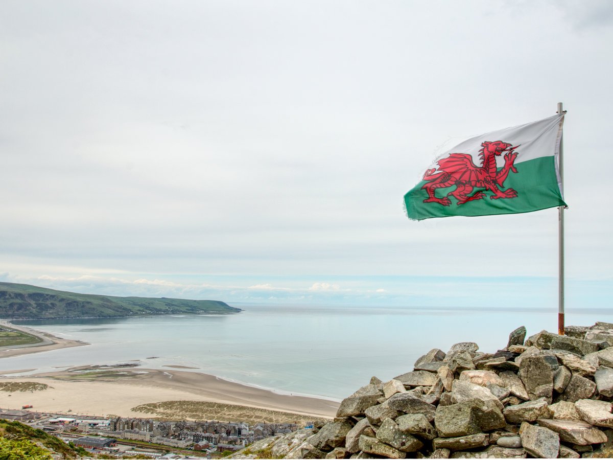
Coed Caffelleast is a peaceful and picturesque strip of woodland atop the hills over Barmouth, quite a nice place to spend some time in its own right, and you won't have far to go to the flag. There are a few rough patches of rock you may need to hoist yourself up onto, but if you pick your path carefully there shouldn't be anything too challenging before you, and as you round the final corner the trees should give way to the Welsh Flag! The views here are stunning, with Barmouth immediately below and, depending on how clear your day is, Fairbourne and Llwyngwril stretching out to the south and the mountainous peninsula stretching out to the North. The flag itself sits atop a stack of stone, mildly precarious but nothing insurmountable should you want your photo with the flag. You'll certainly be spending some time up here snapping photo after photo, a nice reward for a good little climb up the Barmouth hillside. There is another bonus too, your return journey will be absolutely chock-full of similarly astounding views, so as you plod your way back down with gravity on your side there will still be plenty to see and enjoy!


The Barmouth Welsh Flag viewpoint is a great little trip well worth your time and effort, and as mentioned previously, the hills over Barmouth are all worth an exploration - so naturally, if you are looking to extend this walk out then breaking away from the flag and following the various paths further up or along the hills will surely result in great things to see! Heading along the hillside towards the Mawddach Estuary is a great addition, you can check out the great viewpoints there as well as things like the Frenchman's Grave, plus being able to progress further up the estuary still for those hungry for a grand adventure. Of course, Barmouth town is chock full of things to do, and if you want to walk something a little different then crossing Barmouth Bridge is something I always whole-heartedly recommend. All that being said, the ascent to the flag is a nice walk to undertake on its own, so don't feel the need to overstretch yourself; the views you get to enjoy beneath y Ddraig Goch are enough to make this journey a memorable and enjoyable use of a sunny afternoon in Barmouth...


