
Today's walk is generally a more relaxed one, leading away from one of our favourite towns along a beautiful stretch of calm river before doubling back by crossing atop a raging torrent. Betws-y-Coed is a simply stunning town, flanked by dramatic hillsides and mountains all around which gives the landscape a chance to sculpt rivers into grand cascades of white-water, our goal is a simple bridge a little walk away from the town: the Miners' Bridge, but first, we need to get there...
This walk starts from the heart of Betws-y-Coed, which means that getting there shouldn't be too much of a difficult task. Betws-y-Coed sits roughly on the meeting point of the A5 and A470, meaning it is well connected in just about any direction you could want - practically a motorway hub by North Wales standards! Car parks are also abundant relative to the size of the town, with us typically parking on the sizable Cae Llan pay & display car park towards the back of the town, however, today's walk actually starts from the Pont-y-Pair pay & display car park, across the little bridge in the centre of town, so if you can snag a space there then the walk will be right in front of you. Public transport links in the area are rather good, being a well-connected little town pretty much central between all major neighbouring towns, you're sure to be able to find a bus route that can take you right into the heart of the town.


So hopefully you are in the heart of Betws-y-Coed and ready to make your way to the Miners' Bridge, if you haven't already, cross the Pont-y-Pair Bridge in the heart of the town and stop to enjoy those views because the waters below are a great start to the adventure! Over the Afon Llugwy and onto the start of our walk - there are a few walks here, options for all experience levels and lengths, but today we will be taking the most direct route to check out the Miners' Bridge by following the most direct route along the river's edge. Technically this will put us on the blue route (or the red route, at least to begin with) but this isn't a difficult path to follow so don't worry too much about navigation - just keep the river on your left, and if you cross over at the Miners' Bridge then thereafter keep the river on your left again to get back!
The walk along the Afon Llugwy from Betws-y-Coed starts with an impressive elevated wooden walkway, aiding accessibility and giving the area a cool woodland vibe, our visit had the sun shining through the trees on a stunning summer's day with us stopping periodically to enjoy the crystal clear and calm waters from our elevated position. Before long, the smooth pathways give way to an open area with the opportunity to take a seat on some picnic benches or carry onwards, paths will turn away but we want to pass through the kissing gate and into the open field beyond. Paths are still clear and easy to follow but may be slightly rougher in parts as you progress, but there is nothing here I don't think should stop the majority of walkers.

The initial stretch beyond the kissing gate is lovely and serene, the river north of Betws-y-Coed widens allowing it to transition from a dramatic cascade of white water to a bubbling and calm; you will almost certainly find yourself stopping along the way to enjoy the incredible sounds of the water gently passing by this stretch of the river, but our goal is further along... Beyond the gentle meander of the river, you will enter into the woods where the paths take a turn for the rocky, you will almost certainly be able to circumnavigate the worst bits and the better stretches are basically just a smooth rock path, naturally, be cautious if it is wet and keep making forward progress. Before you know it you will be able to catch glimpses of the bridge up the way, especially if you cut closer to the river where the terrain allows, ascend the moderate incline and you will still be staring down the Miners' Bridge.
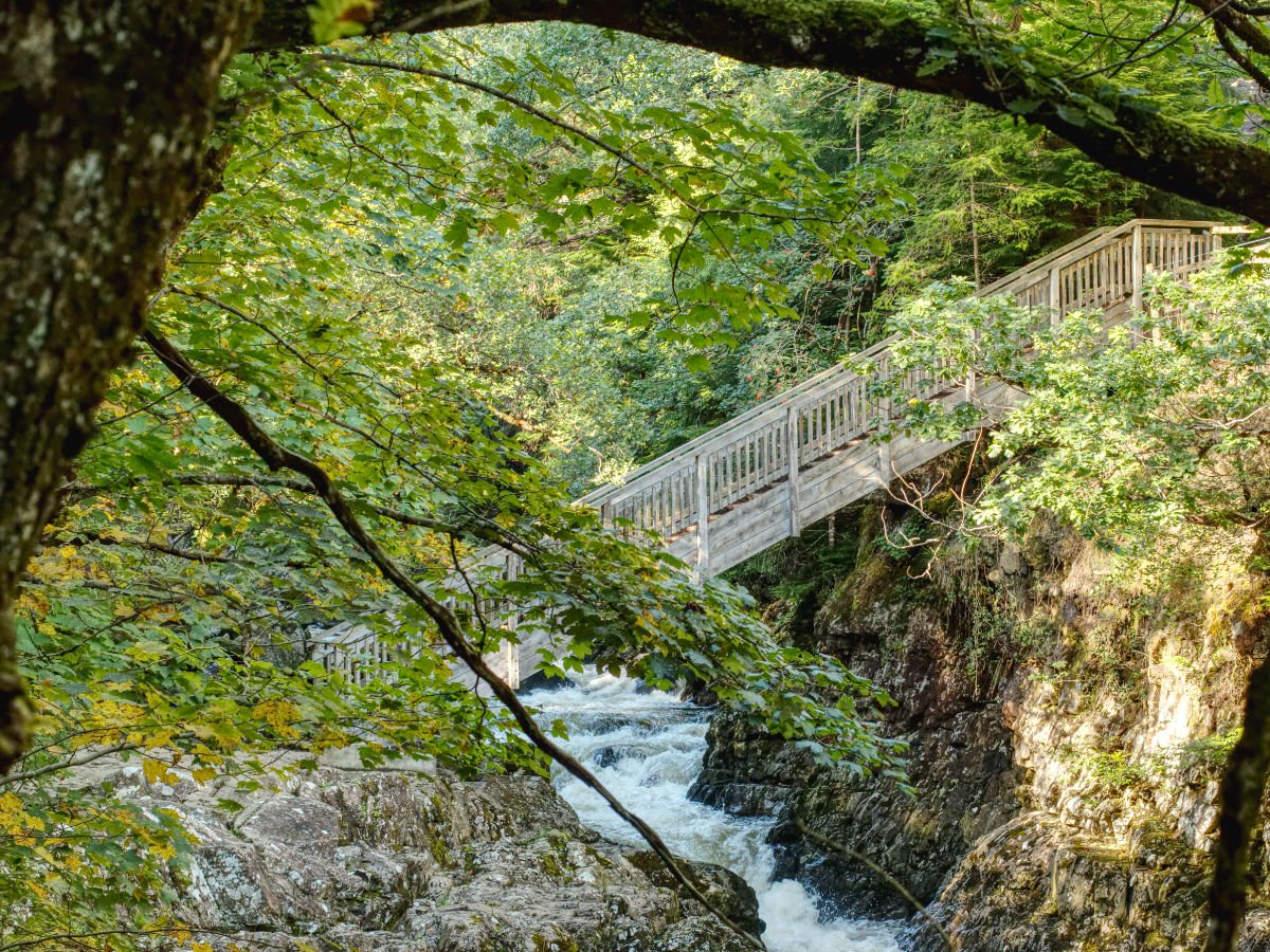
At the top of the Miners' Bridge, you have the option of doubling back on yourself up into the woods and following the walks that way or crossing the bridge to head back to town (well, regardless of the choice you make, I'm sure you will be wanting to cross the bridge and snap some photos first!) - we were after a quicker loop back so we crossed over, but those with more time are absolutely going to want to take the time to explore the woodlands on this side of the bridge. Regardless, make your way across at least once so you can snap some photos from the better vantage points across the bridge. The bridge is pretty unique as far as I know, I cannot remember a time I have crossed a staircase bridge like it. From what I can gather the Miners' Bridge has quite a long history, although the bridge as it stands is a modern construction, as the original one was destroyed in a storm in 2020 - so no worries about crossing a rickety old miner's bodged together crossing, this is only a few years old. On the plus side and to the credit of the workers, the reconstruction is seemingly faithful to the bridge that stood in its place, with pictures of a similar-looking bridge popping up as far back as the early 1900s. Lead Miners litter the area, with Pen-yr allt atop the hillside above the bridge, and the Miners' bridge allowed the workers to get to their job a little easier. Its history beyond this is a little murky, with some claims that a crossing here has existed as far back as the Roman Times. I did some digging into scholarly articles on the subject but came up mostly empty - still, it is a nice thought to think that people could have been crossing the waters on this spot for thousands of years!


As mentioned above, we opted for a quicker route back, so after having descended the Miners' Bridge we continued up the next set of stairs in front and had a brief stretch of woodland to enjoy, with a little stream passing under the road, before we ascended a short set of steps up to the A5. There are paths all along the A5 that will take you straight back to Betws-y-Coed - it is hardly as pretty as the first half of the walk (although the hills and woodlands around the roadside are plenty pretty and do offer additional walk options too) but this is certainly the most efficient way to reach the town again! Once you reach the town you can amble through the shops before returning back to your chosen start point. If you are after a little more to add-on to your day then there are plenty of additional walks all around Betws-y-Coed, with some great waterfalls nearby like Conwy Falls, Swallow Falls, Fairy Falls and Fairy Glen. Swallow Falls is on the stretch of the A5 as the Miners' Bridge, although I don't believe there is a nice way to link to it via the woodlands, instead, you'd be looking at about a 1-mile stretch between where the walk above joins the A5 and Swallow Falls. The loop to the Miners' Bridge on its own is a great way to have a gentle stroll along the river, and between that and the great shops and food around Betws-y-Coed, you are sure to be able to make up one great day out no matter what you chose to do.
